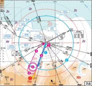
The Minister stated that the flight plan for the ill-fated second flight was an Instrument Flight Rule flight plan from Halim Airport, to the Pelabuhan Ratu area and back, with a planned altitude of 10,000ft. The flight was planned to take around 30 minutes.
Timeline
0710UTC aircraft requested engine start.
0721UTC aircraft took off from Runway 06 and climbed to 10,000ft.
0724UTC aircraft contacted ATC at Soekarno Hatta airport along radial 200 from Halim VOR (VHF Omnidirectional Range beacon).
0726UTC aircraft requested to descend to 6,000ft.
0728UTC aicraft requested to make a right orbit over Atang Sanjaya (Bogor) Training Area.
0752UTC ATC attempted to call aircraft as it disappeared from radar.
0755UTC ATC reported the missing aircraft to the Air Traffic Service Coordinator.
0835UTC SAR “Uncertainty Phase” declared.
0905UTC ATC contacted Search and Rescue
0955UTC SAR “Alerting Phase” declared.
1122UTC “Distress Phase” declared after aircraft endurance time elapsed.
 |
| My flight path analysis/speculation of accident in Part 2 of article series is very similar to the official statements made so far. |
My Remarks
This corelates with my analysis at SSJ100 Accident: Innovent but Deadly Part 2. Everything up to Point 3, matches. However, the descent from 10,000ft does NOT make sense if they planned to go to the Pelabuhan Ratu area, which is about another 25 nautical miles from where the aircraft did its orbit.
Based on this, a rough descent profile analysis can now be assembled, which will be put in Part 3 of the the “Innocent but Deadly” article series. (To be updated/linked here)

